 Assoc.Prof.Dr. Orhan KURT's Web Pages
Natural and Applied Sciences
Geodesy and Geoinformation Engineering Programme
JJM601 Integrated Geodesy (3-0-0)
Geoid and revolution ellipsoid. Horizontal and vertical datums. Topocentric, geocentric ve projection coordinate systems. Reduction of terrestrial observations to surface of the projection. Reduction of terrestrial observations onto surface of the ellipsoid. Reduction of the gravity measurements. Modeling and evaluating the geodetic networks in 2D and 3D. Modeling and evaluating leveling and gravity networks. Modeling and evaluating all measurements, (direction, vertical angel, slope distant, leveling height difference, gravity, relative coordinates from GNSS,…) together. Computing of 3D Cartesian coordinates and their variance-covariance matrix. Transforming the coordinates and variance-covariance matrix to the National datum. Computing precision and quality measures. Testing the integrated mathematical model and the results from the model for outliers.
JJM615 Data Modeling and Analyzing (3-0-0)

Parametric and non-parametric experimental data. Normal and test distributions. Taylor expansion and linear algebra. Criterion functions (Lp-norm). Lagrange criterion function. Solutions of linear equation systems. Hypothesis tests. The first and second types of errors. Soft computing methods. Fuzzy Logic. Artificial Neural Network. Artificial Intelligent. Genetic algorithm.
JJM513 Hypothesis Testing (3-0-0)
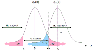
Stochastic (random) process and distributions. Normal distribution. Test distributions; t-distribution, X2-distribution, F-distribution. One and two tailed tests. Confidence region. Criterion functions (Lp-norm, p=1,2,max). Least squares (L2-norm). Mathematical models and their types. First and second type errors in the statistical testing. Linear hypothesis tests. Mathematical models expanded with linear hypothesis tests. Testing the mathematical model. Testing the parameter(s). Outlier tests. Robust outlier tests.
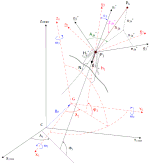
JJM515 Coordinate Systems and Transformations (3-0-0)

This course provides candidates with profound knowledge on; Coordinate systems. Orthogonal, affine and curvilinear coordinate systems and their areas in application. Concept and types of datum. Geoit and ellipsoid of revolution. Motions of the Earth. Concept and types of the time. Wobbles of spin axes of the Earth. Terrestrial, celestial and orbital coordinate systems. Motions of celestial systems. Motions of terrestrial systems. Transformations among coordinate systems of terrestrial and celestial and orbital. Structure and mission of IERS (International Earth Rotational Service). ITRF (International Terrestrial Reference Frame) and ICRF (International Celestial Reference Frame). Transformations in 1D (Dimension), 2D and 3D. Estimation of point velocities and transformations among epochs.